From the vast, untamed wilderness of Alaska to the rapidly evolving frontier of artificial intelligence, a common thread often emerges: the pursuit of understanding. It’s a pursuit that demands ingenuity, resilience, and sometimes, the ability to soar above the challenges, quite literally. In a world increasingly reliant on data to make sense of complex environmental shifts, the fusion of expert piloting and cutting-edge research has become indispensable. This unique synergy is perhaps best exemplified by individuals like Martin Stuefer, the distinguished director of the Hyperspectral Imaging Lab at the University of Alaska Fairbanks (UAF) Geophysical Institute. His career is a testament to the extraordinary blend of precision flying and rigorous scientific inquiry, operating at the very heart of some of our planet’s most critical environmental studies.
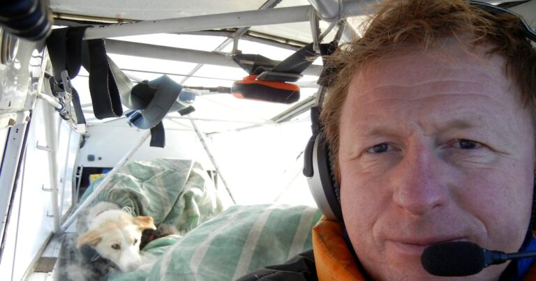
Stuefer isn’t merely a researcher who occasionally uses aircraft; he is a skilled pilot whose cockpit doubles as a mobile laboratory, navigating the challenging Alaskan skies to gather invaluable data. His work transcends the conventional boundaries of academic research, embodying a hands-on, high-stakes approach to environmental science that few can match. Imagine piloting a small aircraft over glaciers, permafrost, and vast boreal forests, not for sightseeing, but to capture intricate details invisible to the naked eye. This isn’t just a job; it’s a calling, merging an adventurous spirit with a deep commitment to unraveling the secrets held within the Earth’s most dynamic ecosystems. As we delve into the world of **scientific aviation**, we uncover a fascinating realm where sophisticated technology meets raw human skill, all in service of a greater understanding of our planet.
Scientific Aviation: Navigating the Skies for Unprecedented Discoveries
At the core of Martin Stuefer’s contributions lies the power of hyperspectral imaging. To truly appreciate the significance of his work, it’s essential to understand what this technology entails. Unlike traditional cameras that capture light in three broad color bands (red, green, blue), a hyperspectral imager collects data across hundreds of narrow, contiguous spectral bands. Each material on Earth – be it a specific type of plant, a mineral, melting snow, or even pollutants – reflects and absorbs light in a unique spectral ‘fingerprint.’ By analyzing these intricate patterns, scientists can identify and map features with unparalleled precision, revealing details that are otherwise undetectable. For instance, hyperspectral data can differentiate between healthy and stressed vegetation, identify subtle changes in permafrost composition, or even detect trace elements in water bodies.
In the vast, often inaccessible landscapes of Alaska, this technology is a game-changer. The state is a natural laboratory for climate change, experiencing some of the most rapid and dramatic shifts on Earth. From thawing permafrost releasing potent greenhouse gases to shrinking glaciers and altered wildlife habitats, the challenges are immense. Ground-based observations, while crucial, are often limited in scope and reach. This is where **scientific aviation** comes into its own. By mounting hyperspectral imagers and other advanced sensors onto aircraft, researchers like Stuefer can cover immense areas quickly and efficiently, gathering consistent data across diverse terrains. This airborne perspective provides a comprehensive, synoptic view vital for understanding large-scale processes and validating smaller, ground-based studies.
The UAF Geophysical Institute, where Stuefer directs his lab, is a nexus for such groundbreaking research. Its mission encompasses everything from seismology and volcanology to glaciology and space physics. Aerial data collection, particularly through hyperspectral and LiDAR (Light Detection and Ranging) systems, plays an increasingly pivotal role in almost all these disciplines. For example, LiDAR uses pulsed laser light to measure distances, creating highly detailed 3D maps of terrain and vegetation. When combined with hyperspectral data, it paints an extraordinarily rich picture of the environment, enabling researchers to track changes in forest canopy, monitor coastal erosion, or assess snowpack depth for hydrological modeling. These insights are not just academic; they inform policy, guide resource management, and help communities adapt to a changing climate.
The Unique Challenges and Rewards of Airborne Research in Alaska
Flying for science in Alaska is an endeavor fraught with unique challenges, demanding exceptional piloting skills and an intimate understanding of the environment. Alaskan weather is notoriously fickle and extreme, capable of shifting from clear skies to whiteout conditions in minutes. Mountainous terrain, vast ice fields, and dense forests present significant navigational hazards. Furthermore, **scientific aviation** missions often require flying at low altitudes, maintaining precise speeds and flight paths to ensure data quality, all while battling turbulence and unpredictable air currents. This isn’t your average commercial flight; it’s precision flying under pressure, often in remote areas with limited infrastructure.
Stuefer’s dual expertise as both a pilot and a researcher is invaluable here. He understands not only how to fly the plane safely but also *why* specific flight patterns and sensor configurations are necessary for optimal data capture. This symbiotic relationship between pilot and scientist ensures that the collected data is of the highest quality and directly addresses the research questions at hand. It’s a far cry from simply hiring a commercial pilot; Stuefer’s deep scientific background allows for on-the-fly adjustments and a nuanced understanding of the mission’s objectives that is critical for success.
The “occasional sled dog” mentioned in the original context might seem like a whimsical detail, but it subtly underscores the rugged, frontier spirit of Alaskan research. It’s a reminder that scientific endeavors in this part of the world often intersect with traditional lifestyles, unforgiving landscapes, and the sheer grit required to operate far from urban comforts. Whether it’s flying supplies to a remote field camp, scouting routes for a dog sled team, or simply navigating around local wildlife, the human element and connection to the vast Alaskan wilderness are ever-present. These experiences, while perhaps not directly related to hyperspectral data, build the resilience and adaptability essential for long-term success in aerial research.
Beyond hyperspectral imaging, airborne platforms in Alaska support a diverse array of studies. Glaciologists use airborne radar to measure ice thickness and internal structures of glaciers, while biologists track wildlife populations, such as caribou herds or migratory birds, using specialized cameras and telemetry. Geologists map fault lines and mineral deposits, and oceanographers monitor sea ice extent and ocean color. The ability to quickly and safely deploy sophisticated sensors across vast, otherwise inaccessible regions makes **scientific aviation** an indispensable tool for understanding and managing the Arctic’s delicate balance. The data collected from these flights contributes significantly to global climate models and informs international efforts to mitigate environmental degradation.
The Future of Airborne Science: AI, Automation, and Global Impact
As an AI specialist and tech enthusiast, I find the intersection of **scientific aviation** and emerging technologies particularly compelling. The sheer volume of data generated by hyperspectral and LiDAR sensors is immense, often presenting a significant challenge for analysis. This is where artificial intelligence and machine learning step in. AI algorithms can process vast datasets exponentially faster than humans, identifying subtle patterns, classifying features, and even predicting future trends with remarkable accuracy. From automated feature extraction to change detection over time, AI is transforming how we interpret airborne scientific data, turning raw numbers into actionable insights.
Furthermore, the evolution of uncrewed aerial vehicles (UAVs), or drones, is also reshaping the landscape of airborne science. While manned aircraft like those piloted by Stuefer remain crucial for large-scale, long-duration missions and carrying heavier, specialized payloads, drones offer unparalleled flexibility for smaller, localized studies. They can fly at even lower altitudes, access dangerous or confined spaces, and operate with greater autonomy. The synergy between manned and uncrewed platforms, guided by AI-driven mission planning and data processing, represents the cutting edge of environmental monitoring.
Looking ahead, the demand for high-resolution, multi-source environmental data will only intensify as our planet faces accelerating environmental changes. Individuals like Martin Stuefer are pioneers, demonstrating the enduring value of human expertise combined with advanced technology. Their dedication ensures that we not only observe these changes but also gain a deep, scientific understanding necessary for developing effective solutions. The future of airborne science is bright, promising even more precise data, faster analysis through AI, and ultimately, a more informed approach to safeguarding our fragile ecosystems.
Martin Stuefer’s career serves as a powerful reminder of the incredible dedication and interdisciplinary skill required to push the boundaries of scientific discovery. By expertly piloting aircraft equipped with state-of-the-art sensors, he and his team at the UAF Geophysical Institute are not just collecting data; they are painting a detailed portrait of a changing Arctic, revealing the intricate processes that shape our world. This work is fundamental to understanding global climate dynamics and ensuring a sustainable future.
The integration of human ingenuity with advanced technology, particularly in the realm of **scientific aviation**, continues to be a cornerstone of environmental research. As we look towards a future where AI augments our analytical capabilities and autonomous systems extend our reach, the pioneering spirit embodied by pilot-researchers like Stuefer will undoubtedly remain essential. Their aerial voyages are more than just flights; they are journeys of discovery, helping humanity navigate the complexities of our planet and inspiring the next generation of scientists and adventurers alike.